🏺 South Asian Protohistoric Historiography
An exhaustive scholarly dissection of the Mature Harappan Civilization (c. 2600–1900 BCE). This treatise examines the standardized urban grid planning of Mohenjo-Daro and Harappa, the unparalleled subterranean hydraulic drainage and domestic wastewater systems, the undeciphered Indus script, metrological binary-decimal weight standards, and maritime trade networks connecting the Indus with the Persian Gulf and Mesopotamia (Meluhha).
In the vast alluvial basin of the Indus and Ghaggar-Hakra river systems spanning modern Pakistan and northwestern India, the Mature Harappan Civilization (c. 2600–1900 BCE) emerged as the most geographically expansive urban culture of the Bronze Age world. Covering over one million square kilometers—dwarfing contemporary Old Kingdom Egypt and Sumerian Mesopotamia combined—the Indus civilization encompassed more than a thousand recorded settlements, ranging from monumental administrative metropolises like Mohenjo-Daro, Harappa, Rakhigarhi, and Dholavira to fortified coastal ports like Lothal and industrial manufacturing workshops like Chanhudaro.
Yet what distinguishes Indus civilization above all its Bronze Age peers is its astonishing degree of urban planning, architectural standardization, and egalitarian civic sanitation. While Egyptian pharaohs exhausted their kingdoms’ wealth erecting colossal stone pyramids for royal tombs, and Mesopotamian priest-kings built towering ziggurats and gilded palace citadels, the Harappans invested their collective civic surplus into high-quality standardized baked brick housing, universal covered sewage drainage systems, civic public baths, and sophisticated reservoir engineering.
This remarkable civilization operated without ostentatious displays of military autocracy. Excavations across dozens of Harappan sites have revealed virtually no monumental royal palaces, grandiose dynastic tombs, or depictions of captive slaughter and warfare. Instead, the archaeological record demonstrates a highly organized, literate mercantile commonwealth guided by rigorous civic regulations, metrological standardization, and an ethos of public health and hygiene that was not equaled until the Roman Empire or Victorian England.
To understand the sheer magnitude of Harappan socio-economic coordination, one must examine the ecological basis of the Indus basin. The Indus River, fed by melting glaciers in the Himalayas and Karakoram ranges, carries massive sediment loads and experiences violent seasonal spring floods. Harappan engineers did not merely endure this hydrological volatility; they mastered it through monumental mudbrick platform construction, elevating entire cities above historical high-water marks and channeling annual inundations to nourish rich winter crops of barley, wheat, lentils, and cotton.
1. Standardized Urban Planning and the Citadel-Lower Town Dichotomy
The urban topography of Mature Harappan cities reflects a deliberate, highly regimented municipal geometry. Unlike the chaotic, organic maze of alleys characteristic of Mesopotamian cities like Ur, Harappan urban settlements were laid out along strict orthogonal grids, with wide arterial avenues oriented precisely along cardinal north-south and east-west axes, intersecting at perfect right angles.
Major Harappan settlements were typically partitioned into two primary walled sectors:
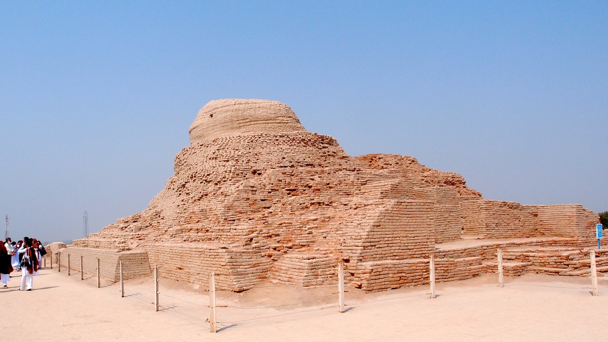
- The Elevated Citadel (Upper Town): Constructed upon colossal mudbrick platforms rising six to twelve meters above the floodplain to protect against catastrophic river inundations, the Citadel served as the civic, administrative, and ritual core. At Mohenjo-Daro, the Citadel housed the iconic Great Bath, the monumental Granary (or Great Hall), and the ‘College of Priests’. The entire acropolis was enclosed by massive fortified walls with watchtowers and formal gated gateways.
- The Expansive Lower Town: Spread out below the Citadel, the Lower Town housed the residential, commercial, and craft-working population. Block-based neighborhoods were partitioned by residential lanes and pedestrian alleys. Houses were constructed around central open-air courtyards, offering privacy, cross-ventilation, and protection against intense summer dust and heat. Blank exterior brick facades faced the streets, with entrance doorways placed discreetly along side alleys rather than primary thoroughfares.
Perhaps the most extraordinary testament to centralized administrative regulation was the universal standardization of building materials. Throughout the entire Harappan territory—across thousands of kilometers from Shortugai in northern Afghanistan to Daimabad in Maharashtra—builders manufactured mud and kiln-fired bricks conforming to an exact mathematical proportion: a thickness-to-width-to-length ratio of 1 : 2 : 4 (typically 7 x 14 x 28 cm for domestic architecture, and 10 x 20 x 40 cm for city walls). This dimensional ratio maximized structural bonding strength (English bond) and modular stability.
The Great Bath of Mohenjo-Daro and Water Ritualism
Unearthed on the Citadel mound of Mohenjo-Daro by Sir John Marshall in the 1920s, the Great Bath represents a masterwork of hydraulic engineering. Measuring 11.7 meters by 6.9 meters with a depth of 2.4 meters, the rectangular basin was lined with finely dressed, tightly fitted bricks set on edge in gypsum mortar. To guarantee complete impermeability, the builders applied an external 2.5-centimeter backing of natural bitumen (asphalt)—the earliest known waterproofing membrane in world history—sandwiched between inner and outer mudbrick retaining walls.
Two monumental brick staircases fitted with timber treads descended into the pool from the north and south. Surrounding the bath stood a colonnaded courtyard flanked by individual private bathing cells and an adjacent brick-lined well that supplied fresh groundwater. A corbeled brick arched culvert allowed the basin to be drained and scrubbed periodically. Because the facility lacked domestic plumbing connections, scholars broadly agree that the Great Bath was not a mundane public swimming pool, but a sacred ritual installation dedicated to communal purification and lustrations—prefiguring the sacred water tanks and temple kunds of subsequent Indian religious tradition.
Adjacent to the Great Bath stood the colossal Great Granary (or Public Hall), measuring 50 by 27 meters. Resting upon 27 brick sleeper piers separated by narrow ventilation air ducts to keep stored cereals dry and prevent rot, this structure served as the central municipal grain reserve—a strategic bulwark against crop failures and a warehouse for dispensing rations to civic workers.
| Harappan Municipal Element | Architectural Material / Mechanism | Engineering Function | Historical & Sociological Significance |
|---|---|---|---|
| Subterranean Sewage Network | Kiln-fired bricks, lime mortar, removable limestone lintels | Evacuation of domestic greywater and blackwater away from living areas | World’s first municipal covered sewer network; public sanitation priority |
| Standardized Brick Ratio (1:2:4) | Alluvial clay fired in wood/charcoal kilns | Modular architectural construction and structural load distribution | Demonstrates empire-wide metrological coordination and craft standardization |
| Great Bath Membrane | Fine dressed bricks, gypsum mortar, 2.5cm asphalt bitumen backing | Complete hydraulic waterproofing for sacred immersion pool | Pioneered advanced petroleum bitumen sealant engineering |
| Dholavira Water Reservoirs | Rock-cut sandstone cisterns, dams, and storm bunds | Harvesting monsoon runoff in hyper-arid Rann of Kutch | Sophisticated rainwater harvesting and civic storage technology |
| Binary-Decimal Chert Weights | Polished cubes of banded Rohri chert | Standardized balance weight calibration for trade goods and taxes | Dual binary (1, 2, 4, 8, 16, 32, 64) and decimal ratio system with <1% variance |
| Lothal Tidal Dockyard | Trapezoidal baked-brick basin (214x36m) with sluice gates | Berthing ocean-going trading vessels during high tide | Oldest engineered port and drydock facility in world maritime history |
2. Hydraulic Engineering: Domestic Wastewater and Covered Drains
The sanitation and hydraulic infrastructure of Indus cities remains one of the crowning triumphs of ancient public health. Nearly every private home in Mohenjo-Daro and Harappa featured a dedicated indoor bathroom equipped with a paved brick floor sloped toward an exterior wall, enabling bathers to wash with water poured from jars.
Wastewater did not drain haphazardly into unpaved streets. Instead, domestic bathrooms connected to vertical terracotta pipes embedded within house walls, which channeled effluent through brick drain chutes into covered masonry catch-basins (soak pits) located beneath the street edge. These catch-basins allowed heavy solid waste to settle to the bottom, while clarified liquid effluent flowed smoothly into the primary municipal sewer line.
Beneath the streets ran extensive networks of covered subterranean drainage channels, constructed of fired bricks laid in lime and clay mortar. The drainage trenches were covered with flat stone slabs or heavy baked bricks that could be lifted by municipal workers to clean accumulated silt and obstructions. At regular intervals, the primary drains discharged into open waterways beyond the city walls. This extraordinary municipal plumbing network prevented contamination of drinking wells and protected urban populations from devastating waterborne epidemics like cholera and dysentery.
In addition to municipal sewers, private dwellings frequently featured ingenious domestic conveniences: second-story bathrooms connected to vertical drainage pipes, private rubbish chutes that dropped household sweepings into masonry street receptacles, and private circular brick-lined wells. Mohenjo-Daro alone boasted an estimated 700 brick wells, ensuring that virtually every residential block enjoyed an abundant, clean water supply.
Dholavira: Master of Rainwater Harvesting
While Mohenjo-Daro and Harappa enjoyed the perennial waters of the Indus River, the island city of Dholavira in the arid salt flats of the Rann of Kutch (Gujarat) faced acute seasonal drought. To sustain a bustling metropolitan center in a hyper-arid climate, Dholavira’s engineers created one of antiquity’s most breathtaking rainwater harvesting networks.
Excavations led by R. S. Bisht revealed that the entire city was encircled by an integrated system of sixteen massive, interconnected rock-cut reservoirs. Builders constructed stone check-dams across two seasonal monsoon torrents (the Mansar and Manhar rivulets), diverting precious flash floods into cascading stone-lined cisterns carved directly out of the underlying sandstone bed. These giant reservoirs, capable of storing over 250,000 cubic meters of potable water, occupied nearly ten percent of the city’s total footprint, ensuring an uninterrupted year-round water supply for thousands of citizens.
Furthermore, Dholavira preserved one of the most intriguing epigraphic discoveries in South Asian archaeology: the Dholavira Signboard. Discovered in a chamber near the northern gateway of the Citadel, the inscription consists of ten large Indus characters, each approximately 37 centimeters tall, meticulously crafted from white crystalline gypsum tiles inlaid into an ancient wooden board that once hung above the ceremonial city gate.
3. Craft Specialization and Long-Distance Maritime Trade
The economic engine of the Harappan civilization was driven by advanced craft specialization and far-flung interregional commerce. Harappan artisans were master metallurgists, stoneworkers, and jewelers, producing items of astonishing beauty and micro-precision:
- Long Barrel-Carnelian Beads: Harappan lapidaries developed specialized bronze drills and diamond-tipped micro-drills to perforate translucent, heated orange carnelian beads up to ten centimeters in length. These luxury beads were prized across the ancient world and exported by the thousands to Mesopotamian royal courts.
- Steatite Micro-Beads and Seals: Artisans carved thousands of square steatite (soapstone) cylinder and stamp seals depicting magnificent realistic animals—including the zebu bull, elephant, rhinoceros, tiger, and the mysterious ‘unicorn’—inscribed with sequences of Indus script. The carved stones were coated with an alkali glaze and baked to brilliant white hardness.
- Bronze Metallurgy and Lost-Wax Casting: The iconic Dancing Girl of Mohenjo-Daro (National Museum, New Delhi)—a delicate, 10.5-centimeter bronze figurine of a young woman resting her hand on her hip and adorned with bangles—demonstrates masterly control of the cire perdue (lost-wax) casting process.
- Shell and Ivory Carving: Coastal settlements like Lothal and Nageshwar specialized in harvesting marine conch shells (Turbinella pyrum) to craft lustrous bangles, ladles, and inlays traded across the interior subcontinent.
The Harappans maintained an active maritime trading network across the Arabian Sea, Persian Gulf, and Indian Ocean. In cuneiform inscriptions from the reign of Sargon of Akkad (c. 2334–2279 BCE), Mesopotamian monarchs proudly recorded that ships from Meluhha (the cuneiform designation for the Indus Valley), Magan (Oman), and Dilmun (Bahrain) were tied up at the quays of Akkad, bringing lapis lazuli, carnelian beads, ivory combs, exotic timber, and gold.
At the port site of Lothal on the Gulf of Khambhat in Gujarat, archaeologists unearthed a colossal trapezoidal brick basin (214 x 36 meters) identified as the ancient world’s first tidal drydock. Fitted with sluice gates, spillways, and mudbrick warehouse wharves, the Lothal dockyard allowed ocean-going wooden vessels to berth at high tide, unload foreign goods, and load Harappan manufactures away from dangerous coastal silt bars.
The Indus Script: The Uncracked Code of Antiquity
Despite over a century of intense philological scrutiny, the Indus Script remains one of the ancient world’s tantalizing uncracked codes. Preserved on over 4,000 inscribed stamp seals, copper tablets, bronze tools, and ceramic pottery shards, the script comprises roughly 400 to 450 distinct signs. Epigraphic concordances compiled by Iravatham Mahadevan and Asko Parpola demonstrate that the script was written primarily from right to left (as evidenced by sign cramming on the left margins of seals).
The primary barrier to decipherment is the brevity of extant inscriptions: the average text is only five signs long, with the longest known continuous inscription on a seal containing just twenty-six characters. Without a bilingual inscription like the Rosetta Stone or the Behistun Inscription, scholars debate whether the underlying spoken tongue was an ancestral Proto-Dravidian language, an archaic Indo-Aryan dialect, or an extinct linguistic isolate. What is indisputable is that the script functioned as an administrative device—sealing merchant bales, verifying cargo ownership, and certifying bureaucratic weights.
4. The Enigma of Social Governance and the ‘Decline’
One of the most enduring mysteries of the Indus Valley Civilization is its political organization. The complete absence of royal palaces, monumental dynastic funerary monuments, and warrior iconography has led scholars to question whether the civilization had kings in the Mesopotamian or Egyptian sense. Leading archaeologists, including Jonathan Mark Kenoyer and Gregory Possehl, suggest that Harappan society was governed not by an autocratic hereditary dynasty, but by a corporate oligarchic coalition: wealthy merchant guilds, administrative scribes, and ritual leaders who shared power through consensus and shared civic regulations.
The famous limestone bust of the ‘Priest-King’ from Mohenjo-Daro—depicting a solemn, bearded figure with a filleted headband, armlet, and a mantle carved with sacred trefoil rosettes—suggests an authority rooted in ritual purity and moral status rather than military coercion.
Around 1900 BCE, the Mature Harappan urban system began to unravel in a process known as the ‘Decline’ or Late Harappan transition. Early twentieth-century theories of an ‘Aryan Invasion’ by chariot-riding nomads have been completely discarded by modern archaeological, genetic, and palaeoclimatological research. Instead, multi-disciplinary evidence reveals that the decline was caused by gradual ecological and climatic shifts:
- Weakening Monsoon Rhythms: Palaeoclimatic speleothem data from caves in northern India demonstrate a prolonged, severe aridification event around 2200–1900 BCE (the 4.2k Year Climate Event), weakening the summer monsoon rains that sustained intensive cereal agriculture.
- River Migration and Desiccation: Tectonic shifts in the Himalayas diverted the seasonal tributaries of the sacred Saraswati/Ghaggar-Hakra river system into the Yamuna and Ganges drainages, drying up hundreds of fertile agricultural oases.
- Decentralization and Ruralization: Facing crop failures and hydrological crises, urban populations abandoned the colossal brick metropolises and dispersed into smaller, rural agricultural villages across Punjab, Haryana, Rajasthan, and western Uttar Pradesh, preserving their metallurgical and cultural traditions in simpler agrarian settings.
🏺 South Asian Protohistoric Legacy
The Indus Valley Civilization bequeathed enduring institutional and cultural legacies to subsequent South Asian history: metrological precision, municipal hygiene standards, terracotta artistry, and iconic religious motifs such as the proto-Shiva Pashupati seal, ritual bath tanks, and the sacred pipal tree (Ficus religiosa). Harappa demonstrated that human ingenuity could build a prosperous, long-lasting civilization founded on civic harmony, sanitation, and commerce rather than military conquest.